Map of France

Le Vernet

French version French Version : http://www.cartesfrance.fr/carte-france-ville/43260_Le Vernet.html

Find a town, a zip code,
a department, a region... in France
I like Map-France.com !


Town of Le Vernet


The village of Le Vernet is a small village located center of France. The town of Le Vernet is located in the department of Haute-Loire of the french region Auvergne. The town of Le Vernet is located in the township of Loudes part of the district of Le Puy-en-Velay. The area code for Le Vernet is 43260 (also known as code INSEE), and the Le Vernet zip code is 43320.

Geography and map of Le Vernet :

The altitude of the city hall of Le Vernet is approximately 1 100 meters. The Le Vernet surface is 3.82 km ². The latitude and longitude of Le Vernet are 45.038 degrees North and 3.672 degrees East. Nearby cities and towns of Le Vernet are : Saint-Bérain (43300) at 3.15 km, Saint-Jean-de-Nay (43320) at 4.21 km, Vergezac (43320) at 4.27 km, Saint-Privat-d'Allier (43580) at 5.32 km, Prades (43300) at 6.27 km, Chaspuzac (43320) at 6.87 km, Saint-Julien-des-Chazes (43300) at 6.99 km, Siaugues-Sainte-Marie (43300) at 7.09 km.
(The distances to these nearby towns of Le Vernet are calculated as the crow flies)

Population and housing of Le Vernet :

The population of Le Vernet was 39 in 1999, 37 in 2006 and 37 in 2007. The population density of Le Vernet is 9.69 inhabitants per km². The number of housing of Le Vernet was 40 in 2007. These homes of Le Vernet consist of 17 main residences, 16 second or occasional homes and 7 vacant homes.
I like Le Vernet !
   

Administrative Information of Le Vernet
Region :Auvergne (83) Map of France regions
Departement :Haute-Loire (43) Map of France departments
 
District :Le Puy-en-Velay 
 
Township :Loudes 
 
Area code :43260 
 
Zip code :43320 
Nearby towns of Le Vernet
Here are maps and information of the close municipalities near Le Vernet.
See all the towns of Haute-Loire (Distances are calculated as the crow flies)
Saint-Bérain (43)  at 3.15 kmSaint-Jean-de-Nay (43)  at 4.21 km
Vergezac (43)  at 4.27 kmSaint-Privat-d'Allier (43)  at 5.32 km
Prades (43)  at 6.27 kmChaspuzac (43)  at 6.87 km
Saint-Julien-des-Chazes (43)  at 6.99 kmSiaugues-Sainte-Marie (43)  at 7.09 km
Saint-Didier-d'Allier (43)  at 7.63 kmCubelles (43)  at 7.95 km
Charraix (43)  at 8.07 kmMonistrol-d'Allier (43)  at 8.14 km
Loudes (43)  at 8.14 kmVazeilles-Limandre (43)  at 8.53 km
Sanssac-l'Église (43)  at 8.54 kmBains (43)  at 8.60 km
Vissac-Auteyrac (43)  at 8.88 kmSaint-Jean-Lachalm (43)  at 9.79 km
Saint-Arcons-d'Allier (43)  at 10.29 kmSaint-Vidal (43)  at 10.96 km

Geography of Le Vernet
Area :3.82 km² (382 hectares) 
Minimum altitude : 1 070 m  
Maximum altitude : 1 301 m  
Average altitude : 1 186 m  
Altitude of the city hall : 1 100 m Map France physical
Sexagesimal geographical coordinates (WGS84): Latitude: 45° 02' 12'' North
Longitude: 03° 40' 18'' East
Decimal geographical coordinates : Latitude: 45.038 degrees (45.038° North)
Longitude: 3.672 degrees (3.672° East)
Lambert 93 geographical coordinates : X: 7 529 hectometers
Y: 64 377 hectometers

Population and housings of Le Vernet
Inhabitants in 1999 :39 inhabitants 
Inhabitants in 2006 :37 inhabitants 
Inhabitants in 2007 :37 inhabitants 
Population data :Population Le Vernet
Population density : 9.69 hab/km² Map of France population density
Variation of population density : -0.66 %/year variation of population density of France
Housings in 1999 :38 logements 
Housings in 2007 :40 logements 
Housings data :Housing Le Vernet


Hotel Le Vernet

Search hotels near Le Vernet : Book your hotel now !

Where ? 

Check-in date 
calendar
Check-out date 
calendar

Book now ! Best Price Guaranteed, no booking fees, pay at the hotel with our partner Booking.com, leader in online hotel reservation.

Find all hotels of Le Vernet :

Hotel Le Vernet

 
Art et Création : Bed and Breakfast near Le Vernet
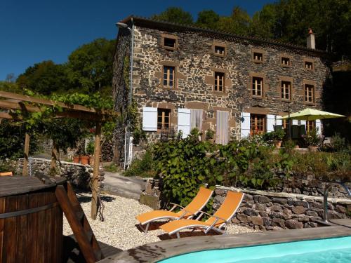
Bed and Breakfast : Art et Création
Located in Bourg Saint-Bérain, Art et Création offers B&B accommodation with a garden, terrace and hot tub. Guests can enjoy the arts and sculptures that were made by the owner ...
Rate : from 90.00 €
Address : Le Bourg 43300 Saint-Bérain
Distance Bed and Breakfast - Le Vernet : 3.14 km

Le clos des pierres rouges : Bed and Breakfast near Le Vernet
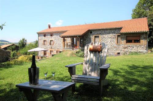
Bed and Breakfast : Le clos des pierres rouges
Situated on St James’ Way, this renovated farmhouse is now a B&B surrounded by a garden with a furnished terrace. Guests are invited to use the sauna or enjoy a drink at the bar...
Contact : lieux dit Rougeac 43580 Saint-Privat-dʼAllier
Distance Bed and Breakfast - Le Vernet : 3.82 km

La Vieille Auberge : Guest accommodation near Le Vernet
Guest accommodation : La Vieille Auberge
La Vieille Auberge is located in Saint-Privat-d’Allier, a 30-minute drive from Le Puy-en-Velay, and features guest rooms with LCD TVs, a meeting room and a traditional restauran...
Prices : from 55.80 € to 98.00 €
Contact : Le Bourg 43580 Saint-Privat-dʼAllier
Distance Guest accommodation - Le Vernet : 5.33 km

Gite-Hôtel La Cabourne : Hotel near Le Vernet
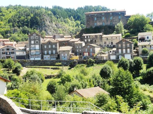
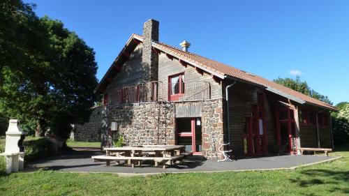
Hotel : Gite-Hôtel La Cabourne  Preferred hotel ! 
Situated on the first official step of Saint James’ Way, 23 km from Puy-en-Velay, La Cabourne features free Wi-Fi access and free private parking. Offering panoramic views of th...
Rate : from 52.00 € to 63.00 €
Contact : Le Bourg 43580 Saint-Privat-dʼAllier
Distance Hotel - Le Vernet : 5.33 km
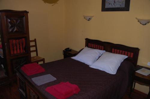
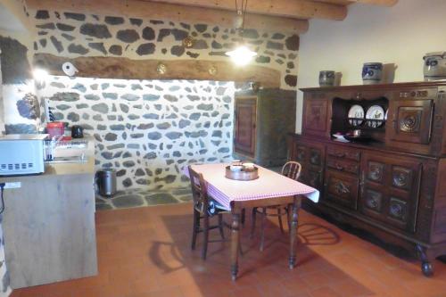
Le Carpé Diem : Guest accommodation near Le Vernet
Guest accommodation : Le Carpé Diem
Le Carpé Diem is located in Saint-Privat-dʼAllier. It offers free WiFi and barbecue facilities. The holiday home has 2 separate bedrooms and includes a kitchen with a microwave...
Address : route de praclaux 43580 Saint-Privat-dʼAllier
Distance Guest accommodation - Le Vernet : 5.34 km

Le Gîte du Velay : Guest accommodation near Le Vernet
Guest accommodation : Le Gîte du Velay
Located in Fay, just 3 km from Bains, this guest house offers a garden of 1500 m². Guests can play table tennis and enjoy the games room. Positioned on St. James’ Way, it is 14 ...
Prices : from 30.00 € to 83.00 €
Contact : Lieu dit Fay 43370 Bains
Distance Guest accommodation - Le Vernet : 6.40 km

La Loge : Guest accommodation near Le Vernet
Guest accommodation : La Loge  Preferred hotel ! 
Situated in Sanssac-lʼÉglise in the Auvergne region, La Loge has a patio and garden views. The accommodation features free WiFi. The holiday home includes 1 bedroom and a kitch...
Contact : 2 rue du mas 43320 Sanssac-lʼÉglise
Distance Guest accommodation - Le Vernet : 8.57 km

le moulin : Bed and Breakfast near Le Vernet
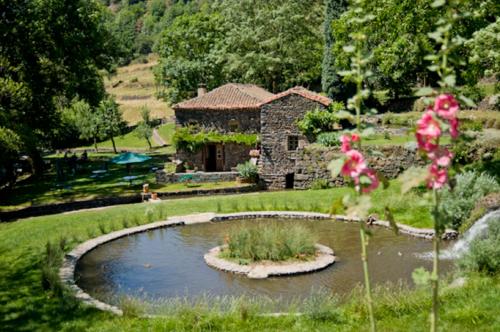
Bed and Breakfast : le moulin
Le Moulin is a B&B located in Saint-Arçons-d’Allier offering a garden and a terrace. Free WiFi access is available. Rooms here will provide you with a terrace. Featuring a show...
Price : from 80.00 € to 105.00 €
Contact : le moulin 43300 Saint-Arçons-dʼAllier
Distance Bed and Breakfast - Le Vernet : 10.15 km

Auberge De Chanteuges : Hotel near Le Vernet
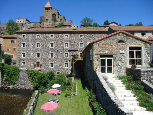
Hotel : Auberge De Chanteuges
Auberge De Chanteuges is 4 km from Langeac, on the Desges River, and features a big garden with a terrace, a game room and a traditional restaurant. A bike garage is at your dis...
Address : 1 Rue des Moulins 43300 Chanteuges
Distance Hotel - Le Vernet : 11.78 km

Auberge de l'Ile d'Amour : Hotel near Le Vernet
Hotel : Auberge de l'Ile d'Amour
Located in Langeac in the Haute Loire Region, Auberge de l’Ile d’Amour offers a terrace, garden and river views. Guests can canoe on the river and Le Puy is a 40-minute drive aw...
Contact : 17 avenue du Gévaudan 43300 Langeac
Distance Hotel - Le Vernet : 14.51 km


Find another hotel near Le Vernet :

Le Vernet hotels list


Map of Le Vernet


Map of Le Vernet :

At right you can find the localization of Le Vernet on the map of France. Below, this is the satellite map of Le Vernet. A road map, and maps templates of Le Vernet are available here : "road map of Le Vernet". This map show Le Vernet seen by the satellite of Google Map. To see the streets of Le Vernet or move on another zone, use the buttons "zoom" and "map" on top of this dynamic map.

Search on the map of Le Vernet :

To search hotels, housings, tourist information office, administrations or other services, use the Google search integrated to the map on the following page : "map Le Vernet".
Hotels of Le Vernet are listed on the map with the following icons: hotel Le Vernet

The map of Le Vernet is centred in the following coordinates :

Latitude :   Longitude :   

Le Vernet on the map of France


Print the map of Le Vernet


Print the map of Le Vernet : map of Le Vernet


Photos Le Vernet

See all photos of Le Vernet :

Other photos of Le Vernet and nearby towns can be found here: photos Le Vernet
These photos taken near the town of Le Vernet can be shown in full screen clicking on the thumbnails. Photos are copyrighted by their owners.

La chapelle Notre-Dame-des-Chazes - Photo of Le Vernet
La chapelle Notre-Dame-des-Chazes

2018-05-16_05-17-41 - Photo of Le Vernet
2018-05-16_05-17-41

2018-05-13_04-59-18 - Photo of Le Vernet
2018-05-13_04-59-18

20170802_180028 - Photo of Le Vernet
20170802_180028

La Chapelle de la madeleine sur les Chemins de Saint-Jacques de Compostelle  à Monistrol d-Allier - Photo of Le Vernet
La Chapelle de la madeleine sur les Chemins de Saint-Jacques de Compostelle à Monistrol d-Allier

La Chapelle de la madeleine sur les Chemins de Saint-Jacques de Compostelle  à Monistrol d-Allier - Photo of Le Vernet
La Chapelle de la madeleine sur les Chemins de Saint-Jacques de Compostelle à Monistrol d-Allier

La Chapelle de la Madeleine sur les Chemins de Saint-Jacques de Compostelle  à Monistrol d-Allier - Photo of Le Vernet
La Chapelle de la Madeleine sur les Chemins de Saint-Jacques de Compostelle à Monistrol d-Allier

Km 552 - Photo of Le Vernet
Km 552

Le bout du tunnel - Photo of Le Vernet
Le bout du tunnel

CHAPELLE SAINT-ROCH - Photo of Le Vernet
CHAPELLE SAINT-ROCH

CHAPELLE SAINT-ROCH - Photo of Le Vernet
CHAPELLE SAINT-ROCH

st jacques  LE PUY- MONISTROL - Photo of Le Vernet
st jacques LE PUY- MONISTROL

dîner au gîte, 5 nationalitées différentes - Photo of Le Vernet
dîner au gîte, 5 nationalitées différentes

st jacques  LE PUY- MONISTROL - Photo of Le Vernet
st jacques LE PUY- MONISTROL


Le Vernet weather forecast

Find next hours and 7 days weather forecast for Le Vernet here : weather Le Vernet (with english metrics)
This is the last weather forecast for Le Vernet collected by the nearest observation station of Loudes.

Week Forecast:


The latest weather data for Le Vernet were collected Saturday, 27 April 2024 at 09:00 from the nearest observation station of Loudes.

Saturday, April 27th

13°C     5°C

47%
 85%


Rain

Temperature Max: 13°C    Temperature Min: 5°C
Precipitation Probability: 47% (Rain)
Percentage of sky occluded by clouds: 85%
Wind speed: 32 km/h North
Humidity: 69%°        UV Index: 3
Sunrise: 06:39     Sunset: 20:46

Sunday, April 28th

11°C     6°C

82%
 98%


Rain

Temperature Max: 11°C    Temperature Min: 6°C
Precipitation Probability: 82% (Rain)
Percentage of sky occluded by clouds: 98%
Wind speed: 5 km/h North
Humidity: 82%°        UV Index: 3
Sunrise: 06:38     Sunset: 20:47

Monday, April 29th

12°C     6°C

84%
 99%


Rain

Temperature Max: 12°C    Temperature Min: 6°C
Precipitation Probability: 84% (Rain)
Percentage of sky occluded by clouds: 99%
Wind speed: 8 km/h North-West
Humidity: 77%°        UV Index: 3
Sunrise: 06:36     Sunset: 20:48

Tuesday, April 30th

14°C     7°C

71%
 98%


Rain

Temperature Max: 14°C    Temperature Min: 7°C
Precipitation Probability: 71% (Rain)
Percentage of sky occluded by clouds: 98%
Wind speed: 16 km/h North-West
Humidity: 73%°        UV Index: 3
Sunrise: 06:35     Sunset: 20:50

Attribution:             


Other maps, hotels and towns in france


Find another town, zip code, department, region, ...


Quick links Le Vernet :


Make a link to this page of Le Vernet with the following code :


Map of France | Regions | Departments | Cities | Partners | Terms | Contact